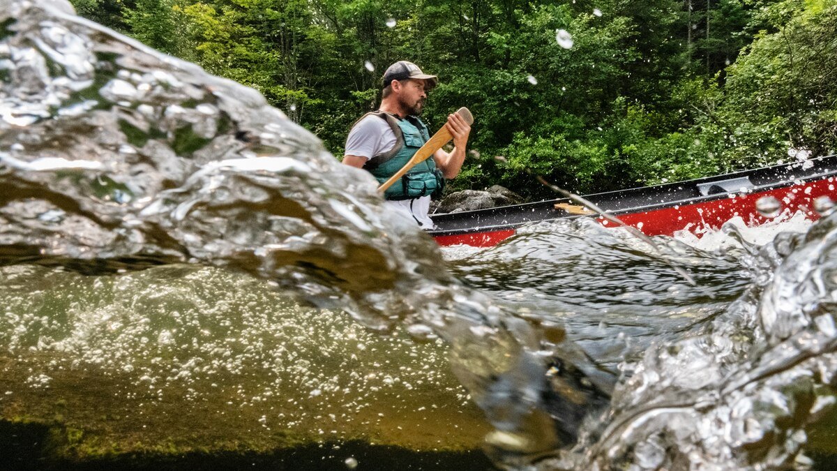
The rain came down in sheets, roiling the surface of Fourth Lake, an oblong crescent in the heart of New York’s Adirondack Mountains and the largest of eight lakes in the Fulton chain. I laid my paddle on my knees and looked around. Our small flotilla of canoes and kayaks, containing a dozen or so paddlers, was spread out over a half mile, though the downpour obscured many of my companions. We were hustling toward the closest takeout, a mile away on Fifth Lake.
Only a few hours earlier, I had shoved off from the tiny hamlet of Old Forge, in upstate New York, pushing east with a group of Native American paddlers along a portion of an ancient route that runs for 740 miles to Maine. The Northern Forest Canoe Trail (NFCT) is made up of a network of more than 80 lakes, ponds, rivers, and streams that snake from Old Forge across the heart of the Northeast, through Vermont, Québec, and New Hampshire, before finally ending with more than 300 miles of travel deep in the woods of Maine. Unlike a lot of canoe trips, this is not a strictly downstream affair but an overland journey too. Many of these waterways are not connected, and so extensive portaging—of one’s canoe, camping gear, and food—is mandatory.
Lucky for us, when we hauled the boats out at Fifth Lake, our first carry was short, just a half mile, and a gas station along the way offered a dry spot to regroup. We left our canoes in a corner of the parking lot. Most of the team huddled inside around hot drinks, while a few smoked cigarettes under an awning out front. Spirits were not high. But there was no easy way to bail.

Browns Tract Inlet, in upstate New York, is among the first of the 23 rivers and streams (and 59 lakes and ponds) that make up the route officially designated as the Northern Forest Canoe Trail (NFCT) two decades ago.
In 2000 a group of paddlers from New England established this long stretch of waterways as the NFCT and began to formally map it. An eponymous nonprofit has spent the 25 years since helping people of all stripes discover one of North America’s greatest canoeing adventures. Of course, the designation doesn’t mean the waterways are just now being utilized for the first time. The communities within the Haudenosaunee Confederacy and Algonquin people, among others, have plied these waters for millennia. Beginning in the 1600s, the same network of rivers and lakes proved vital to European settlers for transportation and expansion of the fur-trapping and timber industries. And in the decades after the Civil War, the very beginnings of the American outdoor recreation ethos began to take root in the area. All for one reason: In this part of the world, it’s easier to travel by water than by land.
(See New England’s vibrant fall foliage on an epic canoe trail.)
I’ve lived in New England my whole life, but I’m a mountain guide and had virtually no canoeing experience. Still, when a friend first told me about the NFCT, it felt like a chance to hike the Appalachian Trail in the 1960s: to experience something wild before it was overrun by weekend warriors and “influencers.” Fewer than 300 people have paddled the trail in one go, and while I never planned to join their ranks, over the course of four months, I traversed hundreds of the trail’s miles on trips led by members of several Indigenous nations.
At the gas station, the hot coffee, cigarettes, and energy drinks kicked in, and our spirits began to rebound. The downpour let up just enough for us to talk each other into heading for the first available campsite—a lean-to three miles away on Sixth Lake at a place called Goff Point. “It’s easier to keep going when you don’t have a choice,” someone said with a shrug.

LIMITED-TIME EARTH MONTH OFFER
Get a bonus issue with all magazines
By the time we arrived, the rain had nearly stopped. We started a fire and sat in a circle roasting hot dogs and drying out our drenched gear. The blaze crackled, sending beams of firelight glittering across the now still surface of the darkened lake. On the opposite shore, we could see headlights weaving along Route 28.
Growing up, Jeremiah Point learned about how his grandparents survived the residential schools—institutions deployed by the U.S. and Canadian governments that took Indigenous children away from their communities to eradicate their cultures, often by violent and abusive means. He also knew that his parents had survived the Indian Day Schools, another assimilative effort. “My generation is the first to not be under an active policy to assimilate and colonize,” he told me. “People think that it happened a long time ago, and it didn’t.”
(They were taken from their families as children. Can that trauma be healed?)
Point did not know the region’s rivers the way his Akwesasne Mohawk ancestors did. That started to change in 2013, when he paddled on the Hudson River in New York State as part of the Two Row Wampum Paddle, an event that commemorated the 400-year anniversary of the original treaty between the Haudenosaunee people and the Dutch. Despite it being his first time on a canoe journey, Point felt a strange sense of déjà vu. Every time he encountered somebody new—whether from the Cayuga, Seneca, or Oneida nations—he had a sense as though they’d met before. The campsites they stopped at along the Hudson’s banks felt like home. “It’s in our DNA,” an elder told him. “Our ancestors did this trip. They were here for thousands of years. That’s why the monarch butterfly can go from Canada to Mexico over multiple generations. They’re not taught that—it’s in their blood.”

As the sun sets on Lower Saranac Lake in New York, Neil Benedict, an Oneida tribal citizen, tends to a fire at Campsite No. 52.
On our trip, Point shared an 18-foot canoe with Ionawiienhawi Sargent, an Akwesasne Mohawk artist on their first canoe journey. Each morning, the pair were the first out of their tents, prepping breakfast and starting the long process of breaking down camp. Ionawiienhawi shared Point’s sense of unity on the water. “It’s a place of connection and prayer,” they told me.
Most of our crew, like Neil Benedict, an Oneida welder, were hoping to make the full two-week trip to Vermont. Others, like Lenny Printup and his then 12-year-old son, Thunder, citizens of the Onondaga Nation, were merely tagging along for the long weekend. And some heard about the trip just 30 minutes before our departure; one fellow was so excited to tag along, he nearly forgot to bring his paddle.
“It is wonderful how well watered this country is,” Henry David Thoreau wrote in The Maine Woods, which was published in 1864 and contains chronicles of three canoe journeys through the Northern Forest, on some of the same passageways that now make up the NFCT. “Generally, you may go in any direction in a canoe, by making frequent but not very long portages.”
An understatement if ever there was one. As the Saranac River ran down out of the eastern Adirondacks in New York, just some 20 miles west of Lake Champlain, whitewater gushing through a gorge forced us to pull off the river and start yet another portage. Although most carries on the NFCT are a mile or less and portage wheels take the bite out of many of them, the carries are often the most challenging part of any canoe journey. Trails can get tight and hilly, and navigating roots, rocks, and foliage while lugging your gear takes as much mental fortitude as it does physical endurance.

While much of the NFCT traverses tranquil lakes, some stretches— including sections of the Rapid River in Maine—are sought out by canoers like Parker Gray for their Class IV whitewater.
For nearly the entire day we trudged in the hot sun down Casey Road. It had hardly rained since the first days of our journey, and the river was unusually low. We were forced to follow the road for eight miles, rather than the more typical five, most of the way to Clayburg, a small village in the already small town of Saranac. For the first few miles, the road was nothing more than a narrow gravel track tunneling through a dense emerald patchwork of June leaves. The river faintly rushed somewhere in the distance. We were beat, and what little conversation we could muster tapered off as we labored along, descending into the first stifling heat wave of summer.
Four miles into the march, the road changed to cracked pavement, and a call broke our trance: “Would you like a lemonade?”
To our right, on a sturdy wraparound porch, sat Holly and Lee Plumadore, a cheerful middle-age couple. The walls were adorned with a collection of vintage signs: lee tires; nasa; our happy place. It was the first house we had seen all morning. We would indeed like some lemonade, we said, grateful for the excuse to set down our canoes and get out of the sun.
The Plumadores both had roots in Clayburg. Lee was born and raised there, while Holly’s grandparents called the village home. She found her way back for good once she married Lee, and the couple settled down near the Saranac. Recently, they’d noticed an increase in boaters journeying down their road. “In the last two or three years is when it’s really picked up,” Lee said, noting that the passersby varied from the occasional adventurer to an almost daily parade of people at the height of summer. The couple started offering refreshments; it just seemed like the neighborly thing to do.
“Some people stop; some don’t,” Lee said, nodding toward the road, simmering in the noon heat. “This can be daunting.”
Later that afternoon, while we were still plodding down the road, an NFCT steward and volunteer named Craig Von Bargen pulled up alongside us with a tractor and a wagon long enough to accommodate all our canoes. He shepherded us downriver and deposited us at a campsite he maintains a short distance from the Saranac.

Most of the NFCT winds through backcountry and secluded forests, but occasionally it crosses areas that have been popular with tourists and locals for decades, like New York’s Lower Saranac Lake.
A few days later, when we trudged into the village of Swanton, Vermont, I said goodbye to Point, Ionawiienhawi, and the rest of my companions. I kept paddling, against the current up the Missisquoi River. The lower water allowed me and Clayton Francis, a lone paddler the group had befriended, to make our way up several easy rapids, wading across pools and dragging our canoes behind us with short sections of rope. As the river wound through farm country and the smell of manure filled the air, the effects of the summer’s drought became obvious: Water levels plunged, and river-bottom rocks, covered in slippery algae, were exposed to foot and canoe alike. Just before the border with Canada, I said farewell to Francis and then quit the river myself.
After several weeks at home, I thought I would return to the NFCT refreshed, ready to take on the last 300-some miles that awaited me in Maine. But the trail’s final miles hold hurdles that have bedeviled paddlers for centuries.
You May Also Like
One morning in the summer of 1857, Joe Polis set out across the Mud Pond carry, a nearly two-mile stretch of land connecting Maine’s Umbazooksus Lake to Mud Pond. A guide from the Penobscot Nation, Polis was leading Thoreau and his friend, Ed Hoar. As immortalized in The Maine Woods, at some point, Polis, hauling the group’s canoe, hustled ahead while the pair of Americans dawdled through the forest. Guideless, Thoreau and Hoar missed a turn and soon found themselves wandering a maze of overgrown logging roads. After reaching Mud Pond, Polis, guessing at what must have happened, doubled back and saved the men from an uncomfortable night lost in the woods.
(These Native American-led tours connect travelers to living history.)
The Mud Pond carry is no less humbling today. It’s far too narrow for portage wheels, so I had to relay my equipment in two loads, turning almost two miles into more than five. It was a theme of the Maine stretch of the NFCT, which took me two trips to complete. On my second, frustrated and a little desperate, I enlisted the company of someone with as intimate a knowledge of these waters as there is.

The Doub family on Raquette Lake in New York.

A view from the Doubs’ boathouse at Bluff Point.
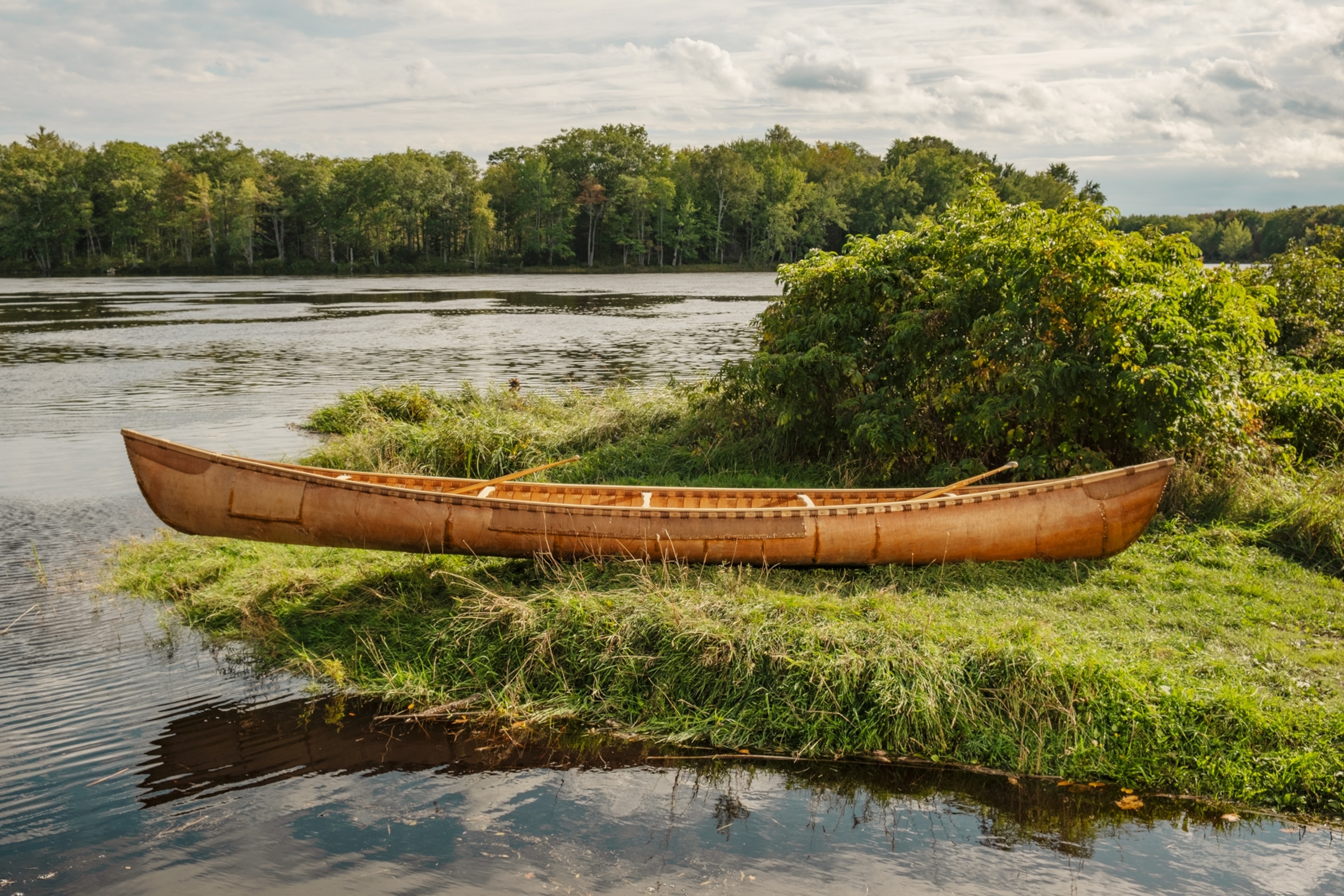
A birchbark canoe built by Penobscot and other Wabanaki tribal members.

The Raquette Lake Supply Co., a common stop for paddlers, thanks largely to Holly Burke and her cinnamon rolls.
Jason Pardilla is a river guide and elected Penobscot council member—he is also Polis’s great-grandnephew. As I set out on the Allagash River with Pardilla, I found he would rather talk about currents than his ancestors. “I’m related to a bunch of cool Penobscots, but I always feel weird” telling their stories, he said. “I don’t mind being recognized for my skills, but I don’t want to be out there being that guy.” Yet, for Pardilla, reading rivers has always been second nature. “I didn’t realize how much I knew until I started guiding, and other people just didn’t see the things that I saw.”
Pardilla and I were joined by James Eric Francis, Sr., the Penobscot historian, and river guides Jennifer Neptune and Ryan Ranco-Kelley, also members of the Penobscot Nation. Where many tribes faced removal and disconnection from their lands and waters, the Penobscot have held on to their place along their namesake river and continued their legacy of canoe guiding.
“Water is freedom,” Neptune said. “We weren’t removed; we were just pushed onto the islands in our river as our territory shrunk down. But in a way it was perfect because it allowed us that freedom to still have our culture. To get in a canoe and take off. That’s what our people did: We just took off.”
That summer, the Allagash’s water table had been reduced to a trickle by the months-long drought, and in shallow water a paddle loses its efficiency. To compensate, the river people of the Northeast use long spruce poles to guide themselves through “skinny water.” Poling makes upstream travel vastly more efficient, a necessary skill for a community that had to think in terms of round-trip canoe journeys, not simply downstream travel.

The NFCT has 65 portaging sections, totaling more than 70 miles across the full trail. This includes a manageable halfmile section between Upper Saranac and Middle Saranac Lakes.
Soon after we started down the river, Pardilla stowed his paddle, picked up a 14-foot spruce pole—skinned free of bark and fitted with a copper end cap—stood up, and began easing his canoe around rocks and strainers, downed trees that can be hazardous to boaters. “It’s the original stand-up paddleboard,” he said with a chuckle.
We later portaged around Allagash Falls, and the landscape started to change once again. The frisky brook trout disappeared; the spruce thinned. And then, quite suddenly, there was a paved road running alongside the river: the first we had seen in a hundred miles. As we pushed on, the Allagash unceremoniously emptied us into the Saint John River. That night, finally, it rained. The next morning, with Pardilla, Francis Sr., and Neptune bowing out due to the weather, Ranco-Kelley and I put down an extra cup of coffee before departing for my final day on the water.
The end of the Northern Forest Canoe Trail can feel strangely abrupt for all the effort one puts in to get there. We glided down riffles of swift water, the current rushing us across great gravel bars. Then we rounded a corner and spied the “friendship bridge” between Maine and Québec—and just beyond it, the boat ramp at Fort Kent, the eastern terminus of the trail. I might have missed the cobblestone landing altogether if not for our friends standing in the rain waiting for us to complete our journey.
The cumulative fatigue from days spent canoeing against gravity and hauling my boat and gear, sometimes for miles, had taken its toll. Most evenings, I fell asleep shortly after nightfall, and I’d come to savor peanut butter by the spoonful, direct from the jar. At some point during my many trips that summer, I had begun to think of the trail not as a series of twists and turns one might expect from a river but a series of steps. Some long and smooth, some short and steep, but always either rising or falling, fighting the current upstream or flowing downhill. Our path on the NFCT followed the water, and the water flowed according to the shape of the land. As Thoreau wrote in The Maine Woods, “Wherever there is a channel for water, there is a road for the canoe.”
On the beach, Ranco-Kelley and I paused for a couple of quick photos, then pulled our canoe ashore and drained the rainwater from its belly. We sloshed up the muddy track, past the old Fort Kent blockhouse to the parking lot beyond, carrying our canoe together.

Remy and Lily de Movellan’s grandparents bought a cabin on Maine’s remote Umbagog Lake 13 years before the NFCT was founded. While canoe traffic has since increased, the place remains a haven of silence and wilderness for the family.
A version of this story appears in the May 2025 issue of National Geographic magazine.
Based in Syracuse, New York, National Geographic Explorer Amy Toensing photographed communities and paddlers along the Northern Forest Canoe Trail. Her last piece for National Geographic was about saving American chestnut trees.